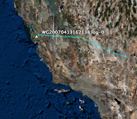
I flew to Las Vegas this morning, and I, er, accidentally forgot to turn off my Sony GPS-CS1. And I sorta accidentally left it on the windowsill of the plane. So I sorta got some data of the trip.
OK now can someone please tell me why you're supposed to turn GPS off in flight? It's not a transmitter, it's a receiver, right? Is it *pulling* data from the satellites, or is it just picking up data in the air, like FM radio? The pilots use GPS. Why on earth would GPS not be permitted to be used in flight?
So since I now, er, had the data, I figured I'd, you know, have a look at it. And here's the curious thing. I have some really cool data on the runway, take-off, and a few points after take-off, but then nada for most of the flight. I got one point somewhere about half-way, (bizarrely enough over a populated area) then once we got close to Vegas, it kicked back into gear again. What gives? Am I completely missing something about how GPS works at high altitudes, in airplanes, at high speeds, or ?? You can download the KMZ file for Google Earth here.
